Software-Tool: PVgrip
PV-GRIP is a distributed service that provides access to geospatial data and performs various computations relevant to photovoltaics (PV). It is originated as a fork of the open-elevation project. However, unlike the open-elevation, PV-GRIP features distributed computation and storage design, handles multiple data types and performs several PV simulations.
Distributed service design
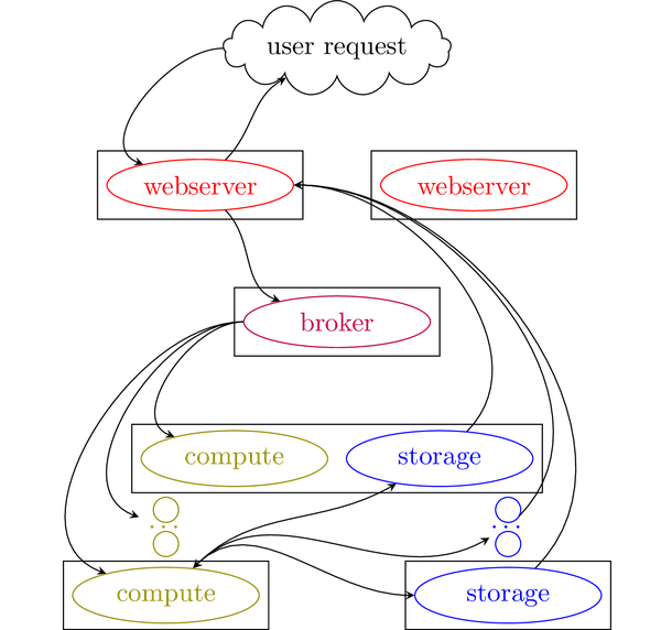
The PV-GRIP consists of several components: webserver nodes (bottle), compute nodes (celery), storage nodes (cassandra and/or ipfs), message broker (redis).The following figure demonstrates the interaction of those components. The webserver listens to the user requests, starts tasks and serves results. The message broker assigns tasks among compute nodes and collects tasks' results. Furthermore, the broker implements the inter-node locking mechanism and a hash table containing records on the current user queries. The compute nodes execute various tasks. The storage nodes handle data exchange between the nodes and implements the spatial index. PV-GRIP can be run on a single computer or multiple machines. Below are provided examples and deployment instructions.
Example: Irradiance map
Computation of a irradiance raster map for a time and given atmospheric GHI and DHI values for a specific location (Kerkrade, Netherlands)
Example: Integrated Irradiance
Modelling of the integrated irradiance over a period of time, provided GHI, DHI and timestamp for same location as in example above.

Example: The longest day in Rurberg, Eifel
This clip tracks the shadow traced on the 21st June 2021:

Contributors
pvgrip and open-elevation:
- Jenya Sovetkin
- João Ricardo Lourenço
- ligi
- Chris Lukic
pvgrip/ssdp/ssdp:
- Bart E. Pieters
pvgrip/weather/copernicus:
- Leonard Raumann
- Neel Patel
pvgrip/osm:
- Nikola Balog
Source:
PVGRIP: https://github.com/esovetkin/pvgrip