Earth System Data Exploration
The research group Earth System Data Exploration (ESDE) develops innovative methods and tools for the integration and analysis of complex, heterogeneous, and big datasets related to air pollution, weather and climate. We work together with the Cross-Sectional Team Deep Learning and the Simulation Laboratories SL Climate Science and SL Terrestrial Systems to apply modern IT methods in order to advance the scientific analysis of earth system data from different observation systems and models. It benefits from FSD activities on federated data services.
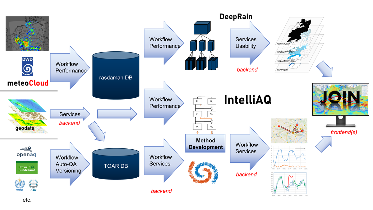
Activities focus on the large international Tropospheric Ozone Assessment Report initiative, for which the ESDE group operates the central data repository and develops high-performance web applications as well as novel analysis methods. Much of this work is funded through the ERC Advanced Grant IntelliAQ. A second line of research investigates the potential of Deep Learning for improving local scale weather prediction (DeepRain project).
The hierarchical infrastructure of geodata web services that is built by the ESDE group contributes to the development of national and international research data management infrastructures. Our aim is to implement true data interoperability. Our applications thus serve as testcase for JSC’s distributed and HPC infrastructures while at the same time providing services of real value to the earth science community and the public. Within the EarthServer Datacube Federation ESDE provides access to its Datacube with numerical forecast data from COSMO model runs.
The research group reaches out to various groups in different Helmholtz centres, is associated with the Geoverbund ABC/J and collaborates with many international research groups, both with respect to earth system science and data management and analytics
The group has strong links to the JSC Simulation Laboratories on Climate Science and Terrestrial Systems and to the Cross-Sectional Team Deep Learning.
Poster on ESDE's topics: Earth System Data Exploration (PDF, 148 kB)
Web services in operation:
- The Tropospheric Ozone Assessment Report (TOAR) database of surface ozone observations (the world’s largest collection of global surface air quality measurements); data accessible through toar-data.fz-juelich.de.
Group members
Alumni
| Ann-Kathrin Edrich | |
| Vincent Gramlich | |
| Severin Hußmann | |
| Dr. Najmeh Kaffashzadeh | |
| Timo Stomberg | |
| Jan Vogelsang |