MesSBAR—Multicopter and Instrumentation for Air Quality Research
Lutz Bretschneider, Andreas Schlerf, Anja Baum, Henning Bohlius, Marcel Buchholz, Sebastian Düsing, Volker Ebert, Hassnae Erraji, Paul Frost, Ralf Käthner, Thomas Krüger, Anne Caroline Lange, Marcel Langner, Andreas Nowak, Falk Pätzold, Julian Rüdiger, Jorge Saturno, Hendrik Scholz, Tobias Schuldt, Rickmar Seldschopf, Andre Sobotta, Ralf Tillmann, Birgit Wehner, ChristianWesolek, Katharina Wolf and Astrid Lampert
Abstract
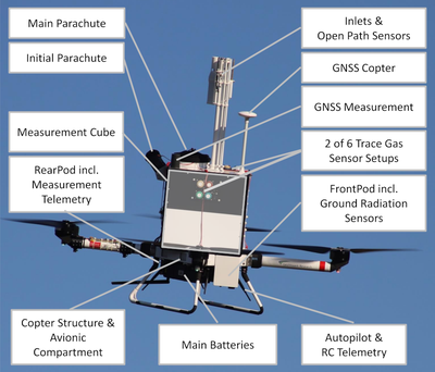
Air quality measurements usually consist of ground-based instrumentation at fixed locations. However, vertical profiles of pollutants are of interest for understanding processes, distribution, dilution and concentration. Therefore, a multicopter system has been developed to investigate the vertical distribution of the concentration of aerosol particles, black carbon, ozone, nitrogen oxides (NOx) and carbon monoxide and the meteorological parameters of temperature and humidity. This article presents the requirements by different users, the setup of the quadrocopter system, the instrumentation and the results of first applications. The vertical distribution of particulate matter next to a highway was strongly related to atmospheric stratification, with different concentrations below and above the temperature inversion present in the morning. After the qualification phase described in this article, two identically equipped multicopters will be used upwind and downwind of line or diffuse sources such as highways or urban areas to quantify the influence of their emissions on the local air quality.