Wüstebach forest station
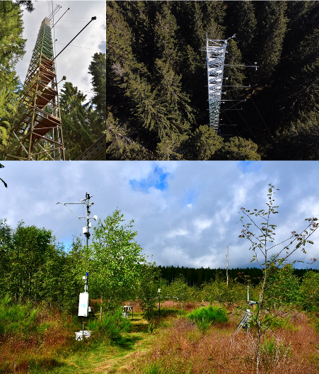
The Wüstebach site (50.504°N, 6.331°E) is located in the Eifel National Park at an altitude of approximately 610 m above sea level and is part of the TERENO observatory “Eifel/Lower Rhine Basin.” It is a forest ecosystem characterized by an approximately 80-year-old spruce forest (Picea abies L.).
The site is integrated into the European measurement network as an ICOS associated site and supplements the ICOS Class 1 sites with valuable data from a montane forest ecosystem. Since 2011, greenhouse gas fluxes (CO₂, H₂O) have been continuously measured using the eddy covariance method. The measurements are taken on a 38-meter-high measuring tower located in the spruce stand. In addition, the tower is equipped with a meteorological profile measurement system that records vertically resolved data on air temperature, relative humidity, and wind speed/direction at various heights.
The site is also part of a comprehensively instrumented catchment area with a long history of measurements. A continuously operating measurement infrastructure has been in place in the Wüstebach catchment area since 2008 to monitor changes in the water, energy, and material balance in detail, particularly in connection with land use changes and renaturation measures. This infrastructure includes several weather stations, three discharge stations, six lysimeters, two cosmic ray soil moisture sensors, and a wireless soil sensor network consisting of several hundred sensors, which enables high-resolution temporal and spatial recording of soil physical parameters, as well as many other measuring devices (see Graf et al., 2014; Bogena et al., 2015).
As part of a renaturation project, the coniferous forest was cleared on a 9-hectare sub-area in 2013 to promote natural repopulation with deciduous trees typical of the site (mainly beech and maple). Since 2013, another eddy covariance station (DE-RuC) has supplemented the measurement concept in the Wüstebach catchment area. The area is now in an advanced stage of natural succession and is characterized by a mosaic-like vegetation structure consisting of herbs, grasses, shrubs, and smaller deciduous trees. The measurement program is supplemented by continuous documentation of tree growth, meteorological measurements, and sensors for soil moisture, soil temperature, and radiation. The constellation of two stations allows direct comparison of carbon and water flows between differently managed or regenerated sub-areas within the same hydrological system. The Wüstebach measurement site as a whole thus serves as an important long-term observation area for studies on the restoration of natural water and material cycles, the effects of land use changes, carbon sequestration in the soil, and biodiversity development in the course of natural succession. The site is a valuable reference point for research into climate-related changes in Central European forest ecosystems.
Regularly updated data on the site can be accessed via data portals:
Further information:
The station on the website of the German ICOS community (ICOS-D)
Interpolated soil moisture data from the SoilNet sensor network in the Wüstebach