Wüstebach forest station
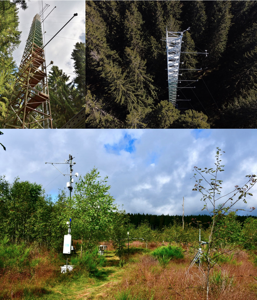
Der Standort ist als ICOS associated site in das europäische Messnetzwerk eingebunden und ergänzt die ICOS Class 1 Standorte um wertvolle Daten aus einem montanen Waldökosystem. Seit 2011 werden kontinuierlich Treibhausgasflüsse (CO₂, H₂O) mittels Eddy-Kovarianz-Verfahren gemessen. Die Messungen erfolgen auf einem 38 m hohen Messturm, der sich im Fichtenbestand befindet. Zusätzlich ist der Turm mit einem meteorologischen Profilmesssystem ausgestattet, das vertikal aufgelöste Daten zu Lufttemperatur, relativer Luftfeuchtigkeit und Windgeschwindigkeit/-richtung in verschiedenen Höhen erfasst.
Der Standort ist zudem Teil eines umfassend instrumentierten Einzugsgebietes mit langer Messhistorie. Bereits seit 2008 wurde im Wüstebach-Einzugsgebiet eine kontinuierlich arbeitende Messinfrastruktur installiert, um Veränderungen im Wasser-, Energie- und Stoffhaushalt detailliert zu erfassen – insbesondere im Zusammenhang mit Landnutzungsänderungen und Renaturierungsmaßnahmen. Diese Infrastruktur umfasst unter anderem mehrere Wetterstationen, ein 3 Abflussstationen, 6 Lysimeter, 2 Cosmic-Ray-Bodenfeuchtesensoren sowie ein drahtloses Bodensensornetzwerk aus mehreren Hundert Sensoren, das eine hochaufgelöste zeitliche und räumliche Erfassung bodenphysikalischer Parameter ermöglicht sowie viele weitere Messeinrichtungen (vgl. Graf et al., 2014; Bogena et al., 2015).
Im Rahmen eines Renaturierungsprojekts wurde 2013 auf einer 9 ha großen Teilfläche der großflächige Rückbau des Nadelwaldes durchgeführt, um die natürliche Wiederbesiedlung durch standorttypische Laubgehölze (v. a. Buche und Ahorn) zu fördern. In diesem Areal ergänzt seit 2013 eine weitere Eddy-Kovarianz-Station (DE-RuC), das Messkonzept im Wüstebach-Einzugsgebiet. Die Fläche befindet sich mittlerweile in einer fortgeschrittenen Phase der natürlichen Sukzession und ist geprägt durch eine mosaikartige Vegetationsstruktur aus Kräutern, Gräsern, Sträuchern und kleineren Laubbäumen. Ergänzt wird das Messprogramm durch kontinuierliche Dokumentationen des Baumzuwachses, meteorologische Messungen sowie Sensoren zur Bodenfeuchte-, Bodentemperatur- und Strahlungserfassung. Die Konstellation mit zwei Stationen erlaubt so den direkten Vergleich von Kohlenstoff- und Wasserflüssen zwischen unterschiedlich bewirtschafteten bzw. regenerierten Teilflächen innerhalb desselben hydrologischen Systems. Der Messstandort Wüstebach in seiner Gesamtheit dient damit als wichtige Langzeitbeobachtungsfläche für Untersuchungen zur Wiederherstellung natürlicher Wasser- und Stoffkreisläufe, zur Auswirkung von Landnutzungsänderungen, zur Kohlenstoffbindung im Boden sowie zur Biodiversitätsentwicklung im Zuge der natürlichen Sukzession. Der Standort ist ein wertvoller Referenzpunkt für die Erforschung klimabedingter Veränderungen in mitteleuropäischen Waldökosystemen.
Regelmäßig aktualisierte Daten des Standortes können über Datenportale abgerufen werden:
Weitere Informationen:
Die Station auf der Webseite der deutschen ICOS Gemeinschaft (ICOS-D)
Interpolated soil moisture data from the SoilNet sensor network in the Wüstebach