
Go to Online-effzett for the latest topics and background information
Where water is becoming scarce
Years of extreme drought and aridity are becoming more frequent. Jülich researchers have investigated at a regional level where water will become scarce in future.

The strawberry fields are still receiving some water, but the nearby corn fields are dry – and no swimming pools are being filled. New long-distance pipelines are supplying water from neighbouring regions and helping to reduce distribution conflicts. Water advisory boards are discussing how the precious commodity can be fairly distributed. This is what periods of drought might look like in the future, with response measures having been planned well in advance.
Things were different in the summer of 2018. The prolonged drought hit the agricultural sector without warning and came close to a natural disaster on a national scale. The German Environment Agency therefore initiated the WADKlim study to investigate the impact of climate change on water availability as well as possible adaptations to drought and aridity. Because one thing was clear: years of water shortages will soon become more frequent, and affected regions will have to develop action plans in advance.

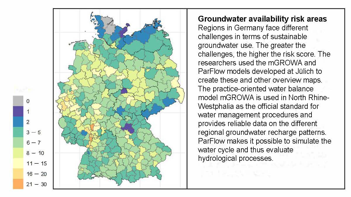
Our simulations show where we are using groundwater resources more intensively than is appropriate during a prolonged drought.
As part of a sub-project of WADKlim, Prof. Stefan Kollet and Dr. Frank Herrmann from the Institute of Bio- and Geosciences (IBG-3) have determined where exactly there will be a lot or little water in future. In an initial study, they not only analysed how much water was available in the districts between 1961 and 2020, but how much of it was used. For the simulations, they used the water balance models mGROWA and ParFlow, which they developed themselves. This enabled them to identify “groundwater availability risk areas” in Germany where there is significant potential for conflicts over water use. These regions range from Upper Lusatia and the Thuringian Basin to Lower Saxony, and can also be found in the Lower Rhine and in the Rhine-Main area. For their analysis, the Jülich researchers investigated the link between water consumption in agriculture and changes in regional groundwater recharge for the first time. “There has never been a nationwide study like this before,” stresses Herrmann. “Our simulations show where we are using groundwater resources more intensively than is appropriate during a prolonged drought.”
But how is climate change affecting the situation? Where might conflicts over water use arise between the population, agriculture, and industry during prolonged periods of drought in 2100? Where, for example, would irrigation in agriculture have to be restricted? These are issues that Herrmann and Kollet addressed in a second study. They developed comprehensive scenarios for this purpose. For example, they took into account future irrigation needs in agriculture, the consequences of climate change on these needs, and how the public water supply might change. “Thanks to this study, we can now better estimate how much water will be available in individual regions in future and to what extent agricultural demand might offset this – while also taking into account various uncertainties,” says Kollet.

Thanks to this study, we can now better estimate how much water will be available in individual regions in future and to what extent agricultural demand might offset this – while also taking into account various uncertainties.
“In principle, water scarcity can affect any region,” says Herrmann. Springs can dry up even in low mountain ranges, as is already happening in Hesse and Bavaria. Other regions may have to build new wells because the groundwater is sinking too low. Or dams could run dry because there is not enough water flowing in during winter. “The infrastructure will have to be adapted in some regions. But we will not run out of water,” Herrmann reassures us. That is why the researcher is reluctant to talk about an impending water crisis, because “these studies allow us to identify and mitigate potential regional conflicts over water use.”
Tool provides support to regions
Herrmann believes that such potential conflicts need to be taken into account during the planning stage for water management systems. The study findings can serve as a basis for strategic and political decisions – right down to the regional level. The researchers have determined the natural water availability with a resolution of up to 100 metres for each individual district.
The Jülich researchers’ studies also provide easily accessible information that regional administrations, water suppliers, and the agricultural sector can use. A quick glance at an overview map highlights the water stress their region is facing; the data can be found on the Jülich DATA platform. “With these data, they are not only able to improve water management, but also identify potential regional conflicts of use and discuss proactive measures,” says Herrmann.
The researchers would like to investigate some aspects in more detail. For example, it is not yet clear how local contamination of groundwater with pollutants reduces water availability or how the water requirements of new drought-resistant crops will affect it. However, with the results currently available, an important step has been taken to ensure that no region is completely unprepared for the next drought.
This text is taken from the 1/25 issue of effzett. Text: Katja Engel; Images: Adobe Stock / Deyan Georgiev, Forschungszentrum Jülich/Sascha Kreklau (2).
Never miss an issue of effzett again


Last Modified: 18.06.2025